Saturday, August 30, 2008

Is That Ike Shaping Up in the Cape Verde Region?

http://icons-pe.wunderground.com/data/images/at200897_sat.jpg

http://icons-pe.wunderground.com/data/images/at200897_model.gif

____________________________________________________
Rod Rodgers _\m/
http://rodndtube.com/

Please consider sponsoring me in the Ride for a Cause surfing contest, on Oct 4th, in Virginia Beach. Many thanks!!!
http://www.marchforbabies.org/rodrodgers

Friday, September 07, 2007

It's Now Official: Subtropical Storm Gabrielle

Statement as of 11:00 PM EDT on September 07, 2007
...Low pressure area off southeastern coast of the United States
develops into subtropical storm Gabrielle...
a tropical storm watch has been issued for portions of the South
Carolina and North Carolina coast from Edisto Beach northward to
Oregon Inlet...including the Pamlico Sound. A tropical storm watch
means that tropical storm conditions are possible within the watch
area...generally within 36 hours.

The Night Before Forecast

Tropical Depression Seven may form today

Posted by: JeffMasters, 9:34 AM EDT on September 07, 2007

An area of disturbed weather (99L) that formed along an old frontal boundary has grown much better organized over the past six hours, thanks to an decrease in wind shear. Strong upper level winds from the southwest are still creating about 15-20 knots of wind shear over 99L, but satellite loops of 99L show that a more organized circulation has formed, with heavy thunderstorm activity starting to build north of the center. The GFS-based SHIPS model is predicting wind shear will fall to 5 knots on Saturday over 99L, and this should allow the storm to organize into a tropical storm by Saturday. The storm may have time to intensify into a Category 1 hurricane before it makes landfall Sunday night in South Carolina or North Carolina, as predicted by the latest run of the GFDL model. However, the SHIPS intensity model and the HWRF models are calling for a tropical storm and tropical depression, respectively, at landfall. My best guess is that this will be a 60-65 mph tropical storm at landfall, but there is a very high amount of uncertainty with this forecast. The storm is then expected to track northward and then northeastward along the coast, bringing heavy rains and high winds to the mid-Atlantic and New England areas on Monday and Tuesday.

The Models the Night Before... finally lot's of similar tracks lining up.

-------------------------------------------------------
SURF SWELL PERIOD WIND WND/DIR
(ft) (ft) (sec) (kts) (deg)
------- -------- ----- ------ --------
9/8 8am 2-5 ESE 109 5.5 8.3 12-16 ENE 77
9/8 2pm 3-6 ESE 113 6.1 8.2 14-19 ENE 71

9/9 8am 3-7 ESE 119 7.9 7.5 16-21 ESE 116
9/9 2pm 2-5 ESE 120 7.0 7.1 13-18 SE 145

9/10 8am 1-3 SSE 157 4.9 6.8 10-14 W 266
9/10 2pm 1-3 S 175 4.0 6.3 7-9 WSW 244

9/11 8am 1-2 SW 216 4.2 5.2 14-19 WSW 249
9/11 2pm 1-2 SW 213 3.5 5.1 12-17 SW 220

9/12 8am 1-2 SSW 207 3.6 5.1 9-13 WSW 242
9/12 2pm 1-2 SSW 205 3.7 5.0 13-18 SW 219

9/13 8am 1-2 SSW 206 3.6 4.8 7-9 WSW 251
9/13 2pm 0-1 SSW 202 3.1 4.7 5-7 SSW 198

9/14 8am 1-2 ESE 106 2.8 8.5 8-11 SSE 158
9/14 2pm 0-1 SSE 168 3.7 4.2 13-17 S 176

Thursday, September 06, 2007

Thu Morning Update on Invest 99

All tracks will support surf for early GP days. Some are obviously better than others. The NWS shows two different tracks, the GFDL and something that looks like the LBAR.
 blog it

Wednesday, September 05, 2007

Wed A.M. Invest 99 Update

This morning's computer models hurricane forecasts for Invest 99 show several different tracks, 2 of 5 which would produce good surf for GP'ers. Two others would produce skim boarding puddles for the new greenster, Blake. Pictured below is the latest North Atlantic Hurricane Coastal Zoom by the NWS [frame grab from Monday, 10 Sept 07). Looks like a Cat 1 or 2 hurricane to me.

Tuesday, September 04, 2007

Gabrielle On The Way?

Invest 99, soon to be a named tropical storm, probably Gabrielle, is consensus forecast to hit the Hatteras area just in time for opening day of GP2K7 (being weather it is always subject to change). Directly below is the buoyweather table forecast and below it are the modeled storm tracks and at the bottom is a NWS WW3 track for Saturday (wind model). Please monitor this development as it could possibly result in a day's delay into the GP house (depending upon whether Hatteras Island evacuates, floods, or permits new arrivals). Buoyweather is showing VAS on Saturday and a nice clean-up on Sunday with strong offshores.

------------------------------------
SURF SWELL PERIOD WIND WND/DIR
(ft) (ft) (sec) (kts) (deg)
------- ----- ------ ------- -------
9/6 8am 2-4 E 85 5.9 6.2 14-20 ENE 58
9/6 2pm 2-5 E 85 6.7 7.0 13-18 ENE 61

9/7 8am 4-8 E 94 8.1 8.5 15-21 ENE 71
9/7 2pm 4-8 E 96 8.1 8.3 16-21 ENE 61

9/8 8am 5-10 ESE 109 10.8 8.3 20-27 E 95
9/8 2pm 6-12 SE 130 12.1 8.9 18-25 ESE 105

9/9 8am 6-13 SE 147 12.2 9.2 17-23 SSW 200
9/9 2pm 4-9 SSE 157 9.0 8.7 18-25 WSW 235

9/10 8am 1-2 SSW 199 4.0 5.8 5-7 WNW 294
9/10 2pm 1-2 SSW 192 3.3 5.9 2-3 WNW 306


Monday, September 03, 2007

End of the Week, Beginning of GP Forecast

A little messy at first, but then we'll find some place ridable:
------------------------------------------------
SURF SURF DIR SWELL PERIOD WIND
(ft) (deg) (ft) (sec) (kts)
------- -------- ----- ------ ------
9/7 8am 2-4 E 89 5.2 7.2 10-14 E 93
9/7 2pm 2-4 E 87 5.3 7.1 11-15 E 83

9/8 8am 3-7 ESE 123 7.4 8.8 18-24 E 84
9/8 2pm 4-9 ESE 117 9.2 8.1 17-23 E 97

9/9 8am 5-10 SE 136 11.5 7.8 23-31 SE 149
9/9 2pm 5-11 SSE 153 12.2 8.1 22-30 S 177

9/10 2am 3-6 SSW 192 8.2 7.0 21-28 WSW 234
9/10 8am 2-4 SSW 197 5.7 6.5 12-16 W 269

Long Range. The storm east of the Lesser Antilles may produce
by the end of GP if it tracks correctly. Nonetheless, there is
other circulation to the east of Hatteras.


Thursday, August 30, 2007

Very Quiet in the Tropics, Maybe One Hope

This is the glimmer of sunshine for GP'ers staying into the week.
Except for Dean, the tropics have been very quiet this year. Nonetheless, Hatteras WILL have some ridable surf.

From the WunderBlog (http://www.wunderground.com/blog/JeffMasters/):
Coast of Africa
None of the computer models are forecasting the development of a tropical depression during the coming week off the coast of Africa. There is a large surge of moisture with tropical waves embedded in it coming off the coast of Africa this week, so we will need to continue to monitor this area for development.


Sunday, August 26, 2007

Thread of Hope in the Distant Future?

Could this be Felix, the wave-maker for GuidoPalooza 2007?

Saturday, August 25, 2007

Dean Sucks Energy Out of Tropical Atlantic???

It is two weeks until GuidoPalooza and it appears that the Cat 5 Dean has sucked all energy out of the tropical Atlantic and doomed GP2K7 to flatness. Oh well, it looked like this last year with 14 days to go.

Here is the NWS WWW3 wave forecast for the Atlantic coast looking 126 hours into the future (8/30/07) on 8/25/07. As the model pans forward in 3 hour increments it increasingly becomes dark blue along the coast. (Click here for links to models.)


This wind model view looks further out into the horizon, 180 hrs. There is finally a hint of action coming off the Cape Verde, but throughout the 180 hours are huge patches of dark blue (representing no wind activity). Maybe we should ask Ferg to burn The Preciouuuuuuuus!

Saturday, August 11, 2007

Watching Dean Develop?

Last Update for Saturday:
Models now forecast the storm to track into the Caribbean.
Blah, Phewwt!


Update:
TROPICAL WEATHER OUTLOOK
NWS TPC/NATIONAL HURRICANE CENTER MIAMI FL
530 PM EDT SAT AUG 11 2007

FOR THE NORTH ATLANTIC...CARIBBEAN SEA AND THE GULF OF MEXICO...

A BROAD AREA OF LOW PRESSURE OVER THE WESTERN CARIBBEAN SEA IS
PRODUCING DISORGANIZED SHOWERS AND THUNDERSTORMS NEAR JAMAICA...THE
CAYMAN ISLANDS...AND CUBA. DEVELOPMENT OF THIS SYSTEM...IF
ANY...IS EXPECTED TO BE SLOW TO OCCUR AT IT MOVES WESTWARD INTO THE
YUCATAN PENINSULA AT ABOUT 10 MPH.

A VIGOROUS TROPICAL WAVE...LOCATED OVER THE FAR EASTERN ATLANTIC
OCEAN JUST WEST OF THE COAST OF AFRICA...IS PRODUCING DISORGANIZED
SHOWERS AND THUNDERSTORMS. CONDITIONS APPEAR FAVORABLE FOR GRADUAL
DEVELOPMENT OF THIS SYSTEM AND A TROPICAL DEPRESSION COULD FORM
DURING THE NEXT COUPLE OF DAYS AS IT MOVES WESTWARD AT 15 TO 20
MPH.

ELSEWHERE...TROPICAL CYCLONE FORMATION IS NOT EXPECTED DURING THE
NEXT 48 HOURS.

$$
FORECASTER RHOME

Hope springs eternal! This forecast is for next Saturday (winds). Hopefully, Dean does not roll over PR and DR.


This image is for swell periods.

Friday, August 10, 2007

Hurting for TS Swell... Something Coming?


"Tropics: An area of tropical disturbance is moving off the West African Coast and has a very good chance of becoming a hurricane over the next three days. If development occurs it will be next weekend before we really start to see the effects of any hurricane swell. This one is definitely worth keeping an eye on, so keep checking back for updates."


Come on, Dean!


Friday, December 01, 2006

Bags of Chips in OBX - Looks Like GPland in Avon

A cargo container that apparently fell off a ship at sea washed up on the Outer Banks of North Carolina today and broke open. Thousands of bags of Doritos brand tortilla chips were strewn along the beach. Scavengers collected the chips, which were apparently still fresh due to their airtight packaging. It was unknown which ship had lost the cargo or to what port it was bound.

user posted image


Brought to us by DaGriz!

Thursday, September 21, 2006

GP2K6 OBX Meets Preciooooous

Sheeee-YIIIIII-EEEETE!!
(Poster by DaGriz)

Many From the Line-Up of GP2K6


Sometimes it was nice like this...


...but early in the week it all too often turned out like this


We also had some clean days...


... and many fast breaking walls


What is not to like?


Waxing Up The Precioooooous


Roast Pig, Corn Chili, Rice, Salad, Wine... a Tradition Continues!!!

The Precious Does GP2K6

Friday, September 08, 2006

Early Arrivals Waiting for the Surf
Edmund (Ohio) announced his arrival to the Outer Banks this afternoon. He reports nil surf but tons of Russian thin, blond babes. Neal reports that Myroni and Jenn (Tidewater, VA) arrive on Friday as well. Neal is planning a Saturday 3am departure with Annapolis Surf Club members Brian Stringer and Giles Cook (all of MD). Beth and I (MD) will be departing just after the sun begins to rise. Griz and Donna (Texas) will be airborne Saturday morning.
Jeff Cahill (NC) might pull in Saturday night. George of the Bush (formerly of the Jungle of HI, now NC) is expected sometime Saturday. Rick Miale (W. NC) is expected on Sunday. Tom Duncan (Calif) is expected to pull in Sunday evening. CraigK (Chicago) flies in on Monday. Kirk "Weekday" Mantay motors in on Wed nite or Thur morning. We simply don't have a clue about the elusive Steve "the Mind" Marshall. SurfSarge is another mysterious soul that has been quiet on AS of late.


Edmunds Says Locals Expect Swell Late Sunday
It might be sooner than that according to many forecasts. Buoyweather.com calls for a Sunday dawn patrol (maybe out in front of the GP shack).

SURF SURF DIR SWELL PERIOD WIND WND/DIR
(ft) (deg) (ft) (sec) (kts) (deg)
---- -------- ----- ------ ------- -------
9/9 8am 1- 3 ENE 70 4.4 6.2 12-16 NNW 347
9/9 2pm 1- 2 ENE 50 4.2 5.8 10-14 N 355

9/10 8am 3- 6 ESE 116 4.6 11.0 6- 8 NW 314
9/10 2pm 3- 6 ESE 117 4.9 11.7 8-10 NE 30

9/11 8am 4- 8 ESE 117 6.6 11.0 16-21 NE 36
9/11 2pm 3- 6 ENE 50 8.3 6.2 17-23 NE 41

9/12 8am 5-10 ENE 60 10.1 8.5 17-24 NE 38
9/12 2pm 5-11 ENE 64 10.0 9.3 14-19 NE 42

9/13 8am 5-11 ENE 72 9.6 10.3 9-13 ENE 77
9/13 2pm 6-12 ENE 74 9.7 11.0 7-10 ESE 105

9/14 8am 5-10 ENE 73 8.3 10.7 17-24 SE 147
9/14 2pm 5-10 ENE 71 8.4 10.3 19-26 SW 222

9/15 8am 3- 6 ENE 72 5.6 10.2 8-11 NW 313

Thursday, September 07, 2006

Water Temps
Duck Pier - 76 degrees
Avalon Pier - 74
Oregon Inlet - 76
Avon Fishing Pier - 76
Hatteras Island Fishing Pier - 77

Thu, 9/7/06 Evening Update: Swell Forecast Still Strong, but Wed/Thu Estimates Appear Optimistic As Florence Projected to Accelerate North

            SURF  SURF DIR  SWELL  PERIOD  WIND     WND/DIR
(ft) (deg) (ft) (sec) (kts) (deg)
---- -------- ----- ------ ------- -------
9/9 8am 1- 3 NE 36 5.2 5.3 16-22 N 354
9/9 2pm 1- 3 NE 32 5.1 5.3 15-21 N 0

9/10 8am 3- 6 ESE 116 5.0 11.1 11-15 NNE 19
9/10 2pm 3- 7 ESE 116 5.4 11.3 11-15 NNE 21

9/11 8am 4- 9 ESE 116 7.3 11.0 17-23 NE 33
9/11 2pm 3- 7 ENE 54 9.1 6.8 19-25 NE 31

9/12 8am 5-10 ENE 62 9.9 8.5 16-22 NE 35
9/12 2pm 4- 9 ENE 64 8.9 8.7 10-13 NE 49

9/13 8am 6-12 ENE 79 9.8 10.5 12-16 ESE 113
9/13 2pm 6-12 ENE 75 9.5 10.6 9-13 SE 135

9/14 8am 5-11 ENE 71 8.8 11.0 13-18 SW 212
9/14 2pm 5-10 ENE 71 8.1 10.9 10-13 SW 221


Buoyweather's Ground Truth Forecasts Are Coming Around
bw's forecasts are usually "oversized" before approaching reality... things are certainly shaping up to a more manageable size for these parts. P.S. Hey Griz, our dear friend Foon is already counseling you and I to not charge overhead Avon on a full tank of G&T's and rhum :) Oh! The nerve!!!


             Surf   SurfDir  Swell  Period  Wind     Wnd/Dir
(ft) (deg) (ft) (sec) (kts) (deg)
---- -------- ----- ------ ----- -------
9/9 8am 1- 3 NE 48 5.7 5.2 18-24 NNE 25
9/9 2pm 1- 3 NE 46 5.9 5.6 17-23 NNE 20

9/10 8am 2- 4 ENE 54 5.7 6.0 14-19 NNE 20
9/10 2pm 4- 8 ESE 117 6.2 11.8 13-17 NE 32

9/11 8am 4- 9 ESE 117 7.6 10.8 15-20 NE 44
9/11 2pm 4- 9 ESE 115 8.0 10.1 15-20 NE 42

9/12 8am 5-10 E 87 9.1 9.2 12-17 ENE 51
9/12 2pm 5-10 E 87 9.0 9.4 12-16 NE 47

9/13 8am 4- 8 ENE 77 8.0 9.3 5- 6 ENE 79
9/13 2pm 4- 8 ENE 75 7.8 9.6 4- 5 ESE 117

9/14 2am 3- 7 ENE 73 6.8 9.5 9 - 13 SSE 163

Thu, 9/7/06 Update: Waves, Waves, Waves... A Good Week to Own a Quicker


            SURF  SURF DIR  SWELL  PERIOD  WIND     WND/DIR
(ft) (deg) (ft) (sec) (kts) (deg)
---- -------- ----- ------ ------- -------
9/9 8am 1- 2 ENE 68 3.7 5.3 10-14 NNE 15
9/9 2pm 1- 2 ENE 66 3.7 5.3 10-13 NE 31

9/10 8am 3- 6 ESE 117 4.8 11.7 13-17 NNE 19
9/10 2pm 3- 7 ESE 116 5.7 11.6 13-18 NNE 28

9/11 8am 3- 7 ENE 62 9.0 6.9 19-26 NE 43
9/11 2pm 4- 8 ENE 67 9.6 7.5 19-25 NE 39

9/12 8am 6-12 ENE 70 11.0 9.4 18-24 NNE 27
9/12 2pm 6-12 ENE 68 10.7 9.4 16-21 NNE 21

9/13 8am 6-13 ENE 69 10.1 10.9 5- 6 ENE 52
9/13 2pm 6-12 ENE 66 9.2 10.9 4- 6 SSW 200


Wednesday, September 06, 2006

Will there be swell this year? Only Florence knows!

SURF SURF DIR SWELL PERIOD WIND WND/DIR
(ft) (deg) (ft) (sec) (kts) (deg)
---- -------- ----- ------ ------- -------
9/9 8am 1- 3 NE 32 4.9 5.2 14-19 N 5
9/9 2pm 1- 3 NE 33 4.7 5.4 11-15 NNE 14

9/10 8am 3- 7 ESE 116 5.2 11.7 12-16 NNE 20
9/10 2pm 3- 7 ESE 116 5.6 11.6 12-16 NNE 23

9/11 8am 5-10 ESE 116 8.2 10.9 18-25 NE 45
9/11 2pm 3- 7 ENE 64 9.1 6.8 19-26 NNE 29

9/12 8am 5-11 ENE 63 11.0 8.5 17-24 NE 39
9/12 2pm 6-13 ENE 78 11.0 9.8 17-23 NNE 25

9/13 8am 7-14 ENE 71 10.8 11.1 7- 9 NE 31
9/13 2pm 6-13 ENE 70 10.4 11.1 3- 4 NE 43

1996: Edouard and Fran. Remember their tracks? Check the Storm Tracker and recall swells from 10 yrs ago! And the similarities with the predicted track of Florence.

Tuesday, September 05, 2006

GP2K6 long range forecasts for Monday

This evening's swell circles for 9/11/06


The swell periods approaching on 9/10/06


The swell periods approaching on 9/11/06


The wind field of the storm on 9/11/06


Source: WWW3 Wave Model Animations (Atlantic)

Deja Vu!? Looks like we will be surfing familiar territory the first few days of GP with forecasted SE swells and strong N winds, if Florence's continues to develop as shown in the models.
            SURF   SURF DIR  SWELL  PERIOD WIND   WND/DIR
(ft) (deg) (ft) (sec) (kts) (deg)
------ -------- ----- ------ ----- -------
9/9 8am 1- 3 NE 49 5.1 5.2 19-27 NNE 28
9/9 2pm 2- 4 NE 48 6.4 5.7 17-23 NE 32

9/10 8am 2- 4 ENE 59 6.7 6.2 15-21 NE 41
9/10 2pm 2- 5 ENE 58 7.0 6.3 14-19 NE 34

9/11 8am 4- 9 ESE 117 7.2 10.8 12-16 NNE 11
9/11 2pm 4- 9 ESE 117 7.4 10.9 15-21 N 3

9/12 2am 4- 9 ESE 116 7.5 10.7 15-21 N 350
9/12 8am 5-10 ESE 112 7.9 10.9 15-21 NNW 344

Monday, September 04, 2006

Long range forecasts for the first day of GP2K6

Late afternoon swell circles for 9/9/06


The swell periods approaching on 9/9/06


The wind field of the storm on 9/9/06

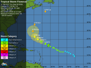
If TD6 (Hurricane Florence) remains on a constant northwesterly track it will bull's eye on Buxton, NC. So worriers and swell hopefuls alike, "When would it make landfall?" The simple answer is Wed or Thu (Sept 13th or 14th).

Here are some basic calculations:

The distance between 22N 59W (the forecasted postion 5 days from now) and Buxton, NC, is 1,355 miles, as the crow flies. Initial heading from 22N 59W to Buxton is northwest (316.0 degrees). At an average speed of 12 mph the storm will advance 288 miles each day, and make landfall in Buxton, NC, in five additional days. In other words, the Wed or Thu of GP2K6.

Update time & distance at Google Spreadsheets "Tropical Storm Time to Landfall."

SteveM's GP2K6 forecasts are holding true so far, but with a little help from Florence that just might change. Today's late afternoon buoyweather projections:

           SURF  SURF DIR  SWELL  PERIOD   WIND   WND/DIR
(ft) (deg) (ft) (sec) (kts) (deg)
--- -------- ----- ------ ------ -------
9/9 8am 1-2 ESE 122 2.6 8.3 6- 8 ENE 65
9/9 2pm 1-2 ESE 123 2.6 8.2 6- 8 ENE 76
9/9 8pm 2-4 ESE 116 3.0 12.6 7-10 E 99

9/10 8am 2-5 ESE 115 3.8 11.1 8-10 E 83
9/10 2pm 2-5 ESE 115 4.0 10.5 7-10 ESE 100
9/10 8pm 2-4 ESE 115 4.0 10.1 7- 9 ESE 123

9/11 8am 2-5 ESE 116 4.1 10.8 7-10 NE 32

Sunday, September 03, 2006

Sun, Sept 3, 2006: TD 6 is now official and forecast to become hurricane Florence in a couple of days. The long range buoyweather forecast for the OBX is:
           SURF SURF DIR  SWELL  PERIOD   WIND   WND/DIR
(ft) (deg) (ft) (sec) (kts) (deg)
---- -------- ----- ------ ------ -------
9/9 8am 1-2 ESE 120 2.2 8.3 4-6 N 7
9/9 2pm 2-4 ESE 115 2.8 13.3 4-5 ENE 54
9/9 8pm 2-5 ESE 115 3.6 12.3 4-6 E 92

9/10 2am 3-6 ESE 116 4.3 11.7 1-2 ENE 78
9/10 8am 3-6 ESE 115 4.7 11.2 5-6 NNE 10
9/10 2pm 3-6 ESE 118 4.7 11.1 5-7 ENE 52

My guess is that these are the beginnings of the Florence swell.


Sat, Sept 2, 2006. Many are braving the wind and surf of Ernesto along the DelMarVa coast. Meanwhile, a new tropical storm is brewing east of the Lesser Antilles that is promising as a swell generator for GP. She likely would be named Florence. My guess at this point is that Florence won't hit the Outer Banks until early- to mid-GP week.

Pre-GuidoPalooza
Sun, Aug 27, 2006. After a quiet, slow season we now have two storms churning in the Atlantic tropics: Debby and Ernesto. Debby is headed north into the central Atlantic and doesn't figure to produce much if any East Coast swell. Ernesto's long range tracks have him running through the Caribbean Sea, into the Gulf of Mexico and maybe across Florida and into the Atlantic or inland and up the Eastern Seaboard. The long-range forecast show two organized tropical disturbances that *could* produce for the GP (see GP Minus 13 days).

In a Nutshell: We will have a good sized contingent at this year's GP... AS'ers from Maryland, Virginia, North Carolina, Texas, Illinois and California (?); and some folks from Balto-DC area. And, a very special guest, the AS Precious Longboard!